
October 29, 2025
I-NET Corp.
-Selected for a Joint Research Project in the Marine and Maritime Fields
by Kure City and Hiroshima University
I-NET Corp. (TSE Prime: Code No. 9600, Head Office: Yokohama, Kanagawa, Representative Director and Executive President: Tomomichi Saeki, hereinafter referred to as "I-NET") has been selected to participate in the FY2025 Marine and Maritime Joint Research Project conducted by Kure City, Hiroshima Prefecture and Hiroshima University.
In collaboration with Hiroshima University, SeatecHIROSHIMA Ltd. ("SeatecHIROSHIMA"), and Marin Craft Kazenoko Co.,ltd. ("Marine Craft Kazenoko")-collectively referred to as the "participating organizations" - I-NET will work to visualize the status of oyster aquaculture by leveraging satellite data and IoT technologies. Furthermore, by applying AI technologies to enhance detection accuracy, the project aims to enable optimal raft management and more efficient fishery operations.
This industry-academia initiative also contributes to safer vessel navigation and disaster risk reduction, supporting the sustainable development of the marine industry.
1.Project Overview
| Project Title | FY2025 Marine and Maritime Joint Research Project - Type B: Research and Development of New Technologies (Kure City & Hiroshima University "Town & Gown" Initiative) | |
| Research Theme | Development of an Optimal Oyster Raft Management and Navigation Safety Support System through Satellite Remote Sensing and On-site Device Integration | |
| Research Period | 2025 to August 2026 | |
| Participating Organizations and Key Roles | Hiroshima University | Leads the overall project and serves as the core in satellite data analysis. Utilizing expertise in SAR satellite image interpretation, the university will develop high-precision detection algorithms powered by AI technologies. |
| SeatecHIROSHIMA | Responsible for hardware development, including enhancements to the low-power beacon device "IKAK," aiming to create a practical prototype capable of maintenance-free operation for one year and stable long-term use at sea. | |
| Marine Craft Kazenoko | Oversees field testing and collaboration with local fishery operators. Promotes a community-based operational model and facilitates location data sharing via smartphone applications. | |
| I-NET | Designs and develops the overall system infrastructure, including cloud services and IoT platforms. Integrates satellite and beacon data to build a visualization system and implements the data coordination framework. | |
| Project Location | Coastal waters around Kure City, Hiroshima Prefecture | |
2. Project Highlights - Visualizing Oyster Rafts through Satellite, AI, and IoT Technologies
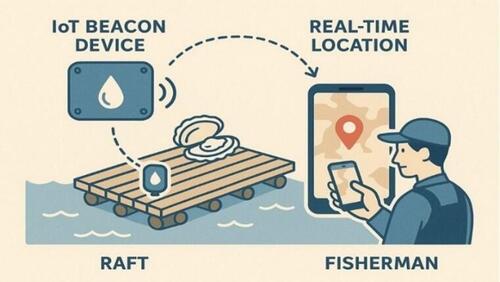
This project integrates Hiroshima University's satellite analysis expertise with SeatecHIROSHIMA's device technologies to develop a high-precision detection system that visualizes the location and quantity of oyster rafts in real time.
| High-Precision Detection with Satellite × AI | Hiroshima University applies AI technologies to improve oyster raft detection accuracy to over 85%, enabling identification of individual rafts even in densely crowded sea areas. |
| Practical Deployment of "IKAK" Field Device | SeatecHIROSHIMA is developing a low-power beacon device that operates maintenance-free for a full year, ensuring stable long-term performance at sea. |
| Community-Driven System Development | Local fishers and vessel operators share data via a smartphone app, demonstrating a new community-led model for maritime safety. |
3.Background - Unseen Risks in One of Japan's Leading Oyster Farming Regions
The coastal waters around Kure City in Hiroshima Bay are among Japan's most prominent oyster farming areas. However, frequent collisions between vessels and oyster rafts - especially during nighttime or foggy conditions - pose serious risks to both fishers and vessel operators.
Current nautical charts do not provide real-time raft location data, and even local authorities lack accurate information on the total number and placement of rafts.
4.Expected Outcomes - Regional Model for Balancing Maritime Safety and Sustainable Aquaculture
By accurately tracking the location and operational status of oyster rafts, the project will help prevent collisions and protect lives. It also enables precise monitoring of aquaculture resources, contributing to sustainable marine resource management. Early detection of drifting rafts and marine debris will reduce both environmental impact and economic losses.
| Enhanced Maritime Safety | Real-time identification of hazardous zones during vessel navigation helps prevent collisions. |
| Advanced Aquaculture Management | Digital monitoring of raft placement and activity enables more efficient operations. |
| Reduced Environmental and Economic Losses | Early detection of drifting rafts and debris minimizes repair and removal costs. |
| Regional DX Model Creation | Promoting a "Marine DX" model through collaboration among government, academia, and industry in Kure City, with potential for nationwide expansion. |
| <Overview of I-NET> | |
| Company name: | I-NET Corp. |
| Location: | 13F YOKOHAMA SYMPHOSTAGE West Tower, 5-1-2, Minatomirai Nishi-ku, Yokohama |
| Business: | Information processing services, system development services and product sales |
| Official website: | https://www.inet.co.jp/ |
<Inquiries >
| For Verification Details: | Yoshikawa Space Solution Division TEL: 81-3-5480-3500 E-mail: sales-space@inet.co.jp |
| For Media: | Enjoji, Fukui, Ito Corporate Strategy and Investor Relations TEL: 81-45-682-0806 E-mail: infomc@inet.co.jp |
DISCLAIMER: This document was prepared using our machine translation, and no manual modification has been made to the translated contents. This document is to be used solely as a reference and in cases where any differences occur between English version and the original Japanese version, the Japanese version shall prevail. The consolidated financial statements in this document are unaudited.